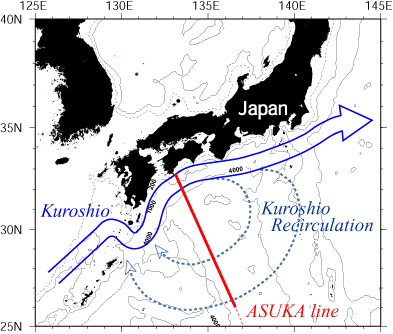
Fig.1 ASUKA observation line across the Kuroshio south of Japan. The ASUKA line (red) was chosen to coincide with a subsatellite track of TOPEX/Poseidon and Jason-1. Schematic flow patterns of the Kuroshio and its recirculation south of Japan are also shown. Contour line of the isobath (200 m, 1000 m and 4000 m) are indicated.
The Kuroshio transport is the transport of the eastward flowing Kuroshio, which is estimated between the Japan coast and the offshore edge of the Kuroshio (maximum 30 degree north). Part of the Kuroshio transport is associated with the transport of the stationary local anticyclonic warm eddy located on the offshore side of the Kuroshio (see Fig. 1).
The Kuroshio recirculation transport, which is assumed to be equal to the eastward transport of the Kuroshio of the northern part of this eddy, is estimated between the offshore edge of the Kuroshio and 26 degree north.
The throughflow transport of the Kuroshio is the transport offset by this local recirculation.
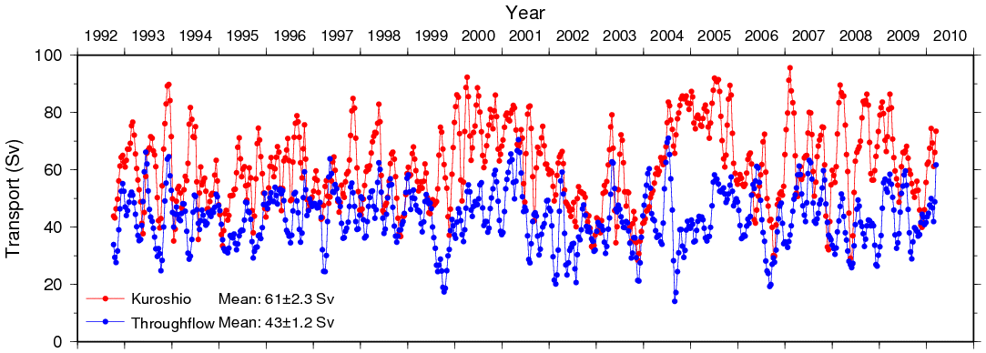
Fig.2 Time series of the Kuroshio transport south of Japan since October 1992. Red line shows the transport of the eastward flowing Kuroshio. Blue line shows the throughflow transport of the Kuroshio. Observation intervals are about 10 days.
The Kuroshio transport and Kuroshio throughflow transport data can be downloaded.
ASUKA_transport_19921007_20100313_20110129.dat(text file)
Used Data
TOPEX/Poseidon and Jason-1 data are delayed-time updated along-tracksea level anomalies (ver 2.0) (AVISO, 2007). The altimetry data was corrected using instrumental errors, environment perturbations (wet tropospheric, dry tropospheric and ionospheric effects), the ocean wave influence (sea state bias), the tide influence (ocean tide, earth tide and pole tide) and inverse barometer correction.References
Sea level data are producted from the Tosashimizu Tide Gauge Station at Cape Ashizuri obtained by the Kobe Marine Observatory. An inverse barometer correction was applied using atmospheric pressure data measured every hour at the Shimizu Weather Station by the Japan Meteorological Agency (JMA).
Imawaki, S., H. Uchida, H. Ichikawa, M. Fukasawa, S. Umatani and the ASUKA Group (2001): Satellite altimeter monitoring the Kuroshio transport south of Japan, Geophys. Res. Lett., 28, 1, 17-20.Links
AVISO (2007): SSALTO/DUACS User Handbook: (M)SLA and (M)ADT Near-Real Time and Delayed Time Products. SALP-MU-P-EA-21065-CLS, ver 1, rev 8.
AVISO Home PageNotes
(http://www.aviso.oceanobs.com/)
JMA Sea level data page (in Japanese)
(http://www.data.kishou.go.jp/kaiyou/db/tide/genbo/index.php)
JMA Atmospheric pressure data page (in Japanese)
(http://www.data.jma.go.jp/obd/stats/etrn/index.php)
If you use the data downloaded from this site, please include a description about the data source and acknowledge it in your articles.
contact to: huchida @jamstec.go.jp